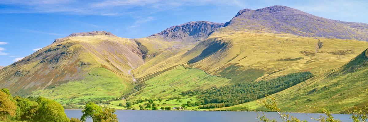
For dramatic scenery, Wast Water reigns supreme over all the other lakes. Perhaps its most striking feature is The Screes, a huge tumble of rocks, crags and boulders rising to almost 2000ft (609m) on the south-eastern side of the lake. Most of the landscape of the Lake District as we see it today was sculpted by glaciers during the ice age, and here at Wast Water, the glacier moving down from the head of the valley seems to have been particularly active; not only did it shear off the side of a mountain to create The Screes, but it also scooped out the hollow of the lake, which, at a depth of 258 feet (59m), is the deepest of the lakes.
The views of the head of the lake are no less impressive, with the pyramid-shaped Great Gable (height 899m) being the most distinctive. Great Gable is Lakeland’s seventh highest mountain; in fact, half of England’s ten highest mountains are arranged around the head of Wasdale, including the two highest, Scafell Pike (978m) and Scafell (964m) which rise to the east of the head of the lake. Of the many routes of ascent to the summit of Scafell Pike, the one from the head of Wast Water is the most direct and shortest at 3 miles each way. However it should be noted that this is a very rough path all the way, and the return trip takes about 5–6 hours in all. The view from the top is worth the effort, taking in most of the Lake District, with glimpses of Derwent Water to the north and Windermere to the east; on the clearest days it can also include the Isle of Man and parts of Scotland, and even occasionally Wales and Ireland.
Many visitors driving to Wast Water will pass through Gosforth which is about 5 miles from the lake. The village is home to one of Cumbria’s most curious ancient monuments, the Gosforth Cross, which can be found in the churchyard at the eastern end of the village. The cross dates back to around 920-950AD, it is made from the local red sandstone and measures 14 feet high (4.4m). The remarkable thing about the cross is that its column is carved with scenes from Norse mythology. These scenes feature several Viking gods, such as Thor, Loki and Baldr, as well as the wolf, Fenrir. The reason for this mixing of Christian symbols and Pagan gods may never be fully explained, but the Vikings were a major influence on the Lake District. They first arrived as raiders in the early 8th Century, but soon became settlers. They are credited with introducing a system of farming which remained little-changed for hundreds of years, and are often credited for bringing the Herdwick sheep too. One way in which their influence remains today is in place names, not just in Cumbria but in many other parts of Britain. Some of the main ones found in the Lake District are: Fell (large hill or mountain), Tarn (small mountain lake), How (hill), Thwaite (a clearing), Force (waterfall).
North of Wast Water is the most westerly of the Lakes, Ennerdale Water. Like its neighbour, Ennerdale is one of the wilder of the lakes, but also one of the quietest. Although there is parking available at the western end of the lake, Ennerdale Water is unique for not having any roads passing along its shores. However this makes the walk around the lake one of the best in the National Park; the route is about 7 miles, but with one tricky section being Angler’s Crag on the south side of the lake.
Beyond the head of the lake the Ennerdale valley stretches for about 5 miles. Much of the valley has been covered by commercial forest plantation, but is now undergoing a process of re-wilding; this involves replacing the conifers with native species, and grazing with cattle rather than sheep. About half way along, the valley is overlooked by Pillar (height 892m), the ninth highest mountain in England. This unusual name comes from the huge slab of rock which stands out on the north face of the mountain known as Pillar Rock, which has been a favourite place for rock-climbers since Victorian times.