On the south-eastern side of Derwent Water, behind the hotel at Lodore is a waterfall which has been famous since the days of the early tourists. This is the Lodore Falls where a stream cascades down through boulders at the bottom of a narrow ravine. Although this is perhaps very different from the archetypal waterfall, the gloomy ravine is very atmospheric, and quite spectacular after a spell of heavy rain
Above the Lodore Falls on the lane to Watendlath are two of Lakeland’s most famous viewpoints. The first is Ashness Bridge, where the old stone bridge forms a perfect foreground for a view of Skiddaw and a glimpse of Derwent Water. Half a mile further on is Surprise View; here the lane has entered woodland and suddenly comes close to the edge of the crags above Lodore, suddenly revealing a panoramic view across all of Derwent Water.
Bassenthwaite & Cockermouth
The most northerly of the lakes is Bassenthwaite Lake, 3 miles north-west of Keswick. This is the fourth-largest of the lakes, and has the unique distinction of being the only one named as a ‘lake”, all the others being named as ‘water’, ‘mere’ or ‘tarn’. This fact is often told as a rather poor joke: ‘Did you know there’s only one lake in the Lake District?…’.
With the busy A66 running along most of the western side of the lake, the best of the walks are to be found on its eastern side where a couple of areas of shoreline are accessible; at one of these can be found St Bega’s Church, which rather curiously, stands in complete isolation a short distance from the lake.
During the summer months many visitors come to Bassenthwaite hoping to see the Ospreys. These magnificent birds of prey migrate here from Africa to nest and breed; they feed on fish by making a spectacular feet-first dive into the water.
Rising up from the eastern side of Bassenthwaite Lake is Skiddaw; at a height of 931m this is England’s fourth highest mountain. Skiddaw and most of the mountains in the north-west of the Lake District are made of slate, and have a different look to the mountains of the central Lakes which are formed from the craggier volcanic rocks. However, Skiddaw’s smoother outlines mean it is more like a giant hill, making it one of the easier mountains to climb. The most popular route ascends from the south via Jenkin Hill, with many people starting from Keswick. This route is about 4½ miles each way, and has been in use for more than 200 years, with many of the early visitors making the ascent on horseback.
The view from the summit is magnificent; being at the northern end of the Lakes, most of the mountains are grouped together in the southern half of the view, which is made even more spectacular when seen from the south end of the summit ridge, as there is also a bird’s-eye view over Keswick and Derwent Water. On clear days there are also views over the Solway Firth to the hills of Dumfries and Galloway in Scotland.
To the north and east of Skiddaw is Skiddaw Forest, one of Lakeland’s great wilderness areas. This tree-less expanse is roughly circular, stretching almost 8 miles across. At its centre is Skiddaw House, built as a shooting lodge in 1829 by the Earl of Egremont; it is said to be the most remote house in England. One of the best walking routes into Skiddaw Forest is by the Dash Valley which curves around the north of Skiddaw, passing the impressive waterfalls of Whitewater Dash.
Around the northern edge of Skiddaw Forest are a number of very attractive villages, the largest of which are Caldbeck, Hesket Newmarket and Bassenthwaite, the village from which the lake takes its name. A few miles to the west along the A66 is the busy market town of Cockermouth. Cockermouth is the northern gateway to The Lakes, and has many fine Georgian houses, one of which, Wordsworth House, was the birthplace of William Wordsworth in 1770, and is now owned by the National Trust.
The old turnpike road from Keswick to Cockermouth passes through the village of Braithwaite and climbs over the Whinlatter Pass. This is unusual amongst Lakeland’s mountain passes in that the top of the road passes through woodland; this is Whinlatter Forest. The woodland here reaches an altitude of just over 500m, making this England’s only true mountain forest. There is a visitor centre at the top of the pass which offers a choice of activities including walking trails, zip wires and some of the country’s most challenging mountain bike routes.
Castlerigg & Thirlmere
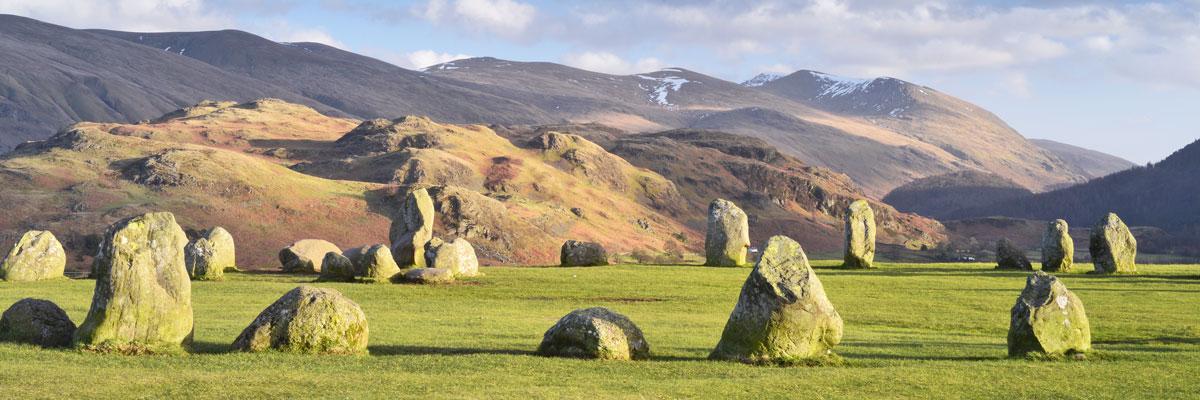
Less than 2 miles east of Keswick is Lakeland’s most famous ancient monument, Castlerigg Stone Circle. This wide circle of 38 stones dates back to about 3000 BC, making it one of the earliest stone circles in the country. Its location is also impressive, standing on a low hill there are stunning views of the mountains on all sides: to the north are Skiddaw and Blencathra, and to the south is Helvellyn. As with all stone circles, the purpose of its construction may never be known, but whether our Neolithic ancestors used the circle for religious rituals, astronomy or simply as a meeting place, there are few better locations they could have chosen in the Lake District.
South of Castlerigg on the A591 is Thirlmere. Thirlmere is actually a reservoir, which until recently supplied water to Manchester. Originally there was a much smaller lake here, lying in the bottom of the valley, but in 1886 the work on the reservoir started, and by stages the water level was raised by about 50 feet. The pipeline which delivers the water to Manchester is one of the un-seen marvels of Victorian engineering; the entire 96 miles being accomplished without pumping, simply using gravity to transport as much as 40 million gallons each day.
North of Thirlmere the valley seems to divide; to the north-west, the Naddle Valley carries the A591 to Keswick, and to the north is St. John’s in the Vale, a classic U-shaped glacial valley, leading to Threlkeld on the A66. These two valleys are separated by a ridge of rocky little hills, and tucked into a dip on the ridge is the church of St John’s in the Vale, one of Lakelands lonely churches. The current building is Victorian, but there has been a church on the site since the middle of the 16th Century. The explanation for the church’s isolated position is that it was able to serve the valleys on both sides from here.
A little further north, and rising majestically above the village of Threlkeld is Blencathra, one of the most distinctive mountains in the Lake District. Its ancient name probably means something like chair summit’, which echoes the mountain’s modern name, Saddleback, both of which are appropriate; when seen from the east the mountain’s double summit has a smooth, grassy dip in between. Although made of slate like Skiddaw, its neighbour to the west, Blencathra is much craggier and has some of the finest mountain scenery in The Lakes. Directly below the saddle, sitting in a deep hollow is Scales Tarn. This dark little lake once had the unlikely reputation of reflecting the stars at mid-day! But what cannot be disputed is that forming the northern rim of the tarn’s hollow is Sharp Edge. This is another challenging ridge, popular with experienced walkers, and is even scarier than the more famous Striding Edge. For the less sure-footed, both the tarn and Sharp Edge can be safely viewed from the path above Scales at the eastern end of Blencathra.